From time to time I find myself participating or helping at Shepherds Dene Riding Mill. Shepherds Dene is a Church of England Retreat House welcoming all. It is jointly administered by the Dioceses of Newcastle and Durham. It is an excellent example of an Arts and Crafts House (think of a smaller Cragside) whose owner gifted it to the church in 1946. It sits on the side of the March Burn Valley 3/4s of a mile up the Slaley Road from Riding Mill. It has prominent resources on the net with its Facebook and website.
On Wednesday 28th September 2011, I joined a one day ramble retreat. A number of photos can be seen here. My summary account there said "Shepherds Dene hosted a ramble retreat led by Reverend Jeremy Chadd on 28th September 2011. 8 miles, 9 persons, three dogs, a welcome from the local landowner Jamie Warde-Aldham at Healey St John, four fords, one bog and six hours passed door to door. Add in breakfast, hearty lunch, afternoon tea and a eucharist for a tenner and Northumbrian Christians know how to offer hospitality and value for money. A series of mini reflections involving Abram, Ruth and Jonah along the line anchored the walkers into the ups and downs of life and faith along a route which cross crossed the March Burn. Two opportunities to repeat are in Shepherd Dene's 2012 programme."
In this blog the opportunity is being taken to describe the route in more detail. The walk is being offered again as part of the Shepherds Dene 2012 programme. It could be undertaken by groups or individuals independently of those opportunities. Shepherds Dene offers an excellent secure start/end for the walk which itself affords a very worthwhile introduction to the valley of the March Barn which is not exactly well known. For those staying at Shepherds Dene, the walk offers a nice day out.
How might it be categorised? If it was part of a county organised programme or a walking festival it would be rated medium. As the crow flies it is about 2 1/2 miles from Shepherds Dene to Healey Church. The walk's strength is its encounters with the valley of the March Burn with four crossings. The walk is not a straight line and this makes it around 8 miles.
The context is that of one of the north running burns/rivers that feed the Tyne between Hexham and Blaydon (Tyneside). The principal five are a group comprising the Devils Water which the A695 crosses at Dilston, that is the largest. The March Burn crossed at Riding Mill. The Guess Burn crossed at Stocksfield with a catchment running up through Apperley Dene to Whittonstall. The Stanley Burn joining the river at Wylam and running behind Prudhoe. The Blaydon Burn. All offer attractive walks and beyond the local area are not well known.
The March Burn catchment extends from Riding Mill (where it is called the Riding Mill Burn) past the policies of Shepherds Dene (where it is the March Burn). It then joined by the Dipton Burn (a glacial meltwater channel) and so drains an area up to the Derwent watershed mostly comprised of Broomhaugh and Riding, Slaley and Healey civil parishes.
The walk is entirely on the OS Landranger 87 Hexham sheet. For the larger scale Explorer sheets, it straddles the boundary of three. You will need 307 Consett, 316 Newcastle and OL43 Hadrian's Wall. If walking in association with Shepherds Dene, the retreat house has a 1:25,000 Explorer sheet printed on demand with the house at the centre. All the walk is on this sheet.
Go well shod. Most of the walking is on sound paths but there are some elements crossing the valley which can be muddy. No fording is necessary, footbridges exist at all four crossings, the fords are optional. But the approach paths can be wet, muddy and quite steep for up to a couple of hundred yards at a time. This write up describes the walk from Shepherds Dene. It is all on public rights of way save for the accesses to Shepherds Dene. The walk could commence in Riding Mill where bus and train services exist. This will add a further 3/4 mile in each direction. The advantage of using Shepherds Dene for any group is that catering, parking and a warm welcome can be assured. At the end of the day a chance to unwind on the patio with a drink from the bar looking across to where one has been is singularly pleasant.
The walk starts from Shepherds Dene's front door and heads north east up the entrance drive (not the exit one) to the Slaley Road. The road is then walked for 1 3/4 miles to NY993595. This is the most sustained public road walking on the route and care should be exercised. Turn left onto the bridleway and descend through Todburn Wood to the first burn crossing. Continue to ascend through woods until a field is reached. A path is indicated at a junction right. Use this along the edge of the field and wood. This will then re-enter the wood, descend and cross the burn again. At this crossing, the road has become a minor access road to a house. Follow it back uphill and along a minor climbing ridge through pasture (livestock). You reach a gated T junction. Turn left and start descending again. As you re-enter the woods note that the public path veers right. This can be missed and the next couple of hundred yards are probably the trickiest bit of the walk. You descend to Healey Mill which is very well preserved and probably seen by only a few hundred passers by a year. From the footbridge here the rock cut gorge heading upstream is dramatic. Across the bridge join the access drive to the mill and turn right, ascend again. Some bends follow but keep to the marked right of way. The alert will realise that Healey Hall is conspiciously in view and that the route will pass this. Do not walk straight to it leaving the right of way. The landowner has welcomed Shepherds Dene personally to this walk and unless permission has been sought users are respectfully requested to stay on the path.
The path is now heading SSW to join a public road from Slaley to Scales Cross at NY992570. Turn left along it. You climb slowly to the summit of the walk at 211 metres. Extensive views north are on offer. Walk the road for just a kilometre to Lane House. A tarmac road turns left and you will use it descending gently. As notices advice, this is a public path and not a public road. Therefore it is a quiet and a pleasant walk. It is the road through the Healey Hall estate. On the approach to Healey Hall, it and the walker should turn right. After just over another kilometre you will reach the few houses and the church that form the nucleus of this most unnucleated village. The church was built in 1860 and despite its apparent lack of potential congregation remains very much in use and in good condition. Please respect it.
If the walk has been arranged through Shepherds Dene, this point about two thirds of the way around, is identified as the major break point. A picnic lunch can (and has been) served, a church service can be arranged, and for those wishing to break their walk, this is a good rendezvous point. So after the refreshment spiritual as well as physical the walk continues by turning right along the minor (now public) road outside the church. In one hundred metres turn left along another public road. Walk 300 metres until a public path is signed heading north through at the moment young woodland. This is called Broomleyfell Plantation. Good views can be had north. After about a kilometre a public road is met at NZ012697. Turn left and within a hundred metres execute a sharp right down a public path using the tarred access road to High Plains. Follow this path which will turn left and make its way straight through the car parking area of High Plains in front of the farmhouse.
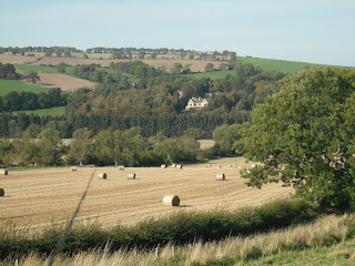
Be careful here to follow the path signs. The whole route is well signed but a word of caution, there have been plenty of stiles along the way. The path is signed around the north side of an exercise paddock and so towards Hemmels Fell. The route is basically west now for a kilometre. Two diverging paths are met, keep right downhill. Shepherds Dene will soon come into view about a kilometre north across the valley (see heading photo). As you leave the wood the path is clear running between two field boundaries. The Riding Mill area is notorious for its spring lines. Descending the hill possibly crosses some of these and can be wet underfoot. A gate into a pasture lies obviously ahead and through this gate can be found the worst conditions especially if cattle are in the field.
You are nearly back. The path descends through pasture to the last ford and footbridge. A small notice here advises about permissive paths direct to Riding Mill. To get to Shepherds Dene, there are two choices. Either continue north on the clearly signed path and you will reach the public road where you turn left and so into Shepherds Dene in another 400 metres. Alternatively having passed the gate north of the ford, it is possible without crossing any fences to use a physically present path beside the March Barn and through woodland into the Shepherd Dene property at the bottom of what is called the Woodland Walk. There are no rights of way through Shepherds Dene and this link is not a right of way.
That should help you around the walk armed with appropriate maps. You will see some wonderfully quiet countryside, a surprising amount of rocky cliffs and in season plenty of juicy blackberies. And if you have teamed up with Shepherds Dene a spiritual guide can make all the links to life's ups and downs whilst the catering arm will ensure you enjoy very wholesome "Northumbrian Farmhouse" fare. Your contact at Shepherds Dene is George Hepburn.


No comments:
Post a Comment